Jamerau (Kuyavian-Pomeranian Voivodeship, Poland)
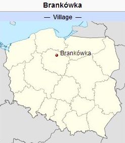
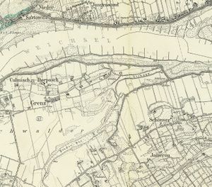
Jamerau (also known as Jamberau, Brankowy, Brankau, and Jamrau, now known as Brankówka; coordinates: 53.40983° N, 18.61553° E [53° 24' 35.4" N, 18° 36' 55.9" E]; population in 1905, 163), a village situated near the Vistula River in West Prussia, belonging to the territory of Culm (Kulmerland, now Ziemia Chełmińska). Jamerau was settled by Dutch Mennonite farmers as early as 1597. The oldest lease was not preserved; in the lease of 1626 the following names are found (some of them may have been garbled): Joachim Rothe, Joachim Leskau, Hans Fott, Steffen Baltzer, Michel Decker, Hans Zimmermann, Ertman Stubbe. The Mennonites of Jamerau belonged to the Schönsee congregation. In 1752 the burgomaster and city council of Culm renewed a lease with the tenants Cornelis Frans, Johan Voet, Johan Nagtigal, Jakob Wedel, Peter Sievert, and Andreas Kurk, which obligated these tenants to keep the dikes along the Vistula in good condition. These tenants were all Mennonites, who (or whose parents) had fled from Lithuania about 1732. Abraham Nickel of Jamerau, a deacon of the Schönsee congregation, in 1806 presented a gift of 30,000 Talers to King Frederick William III and Queen Louise of Prussia, then fleeing before Napoleon, as a proof of the loyalty of the Mennonites in this district.
Bibliography
Duerksen, J. A. "Przechowka and Alexanderwohl." Mennonite Life 10 (April 1955): 76-82.
"Familienforschung in Westpreußen." Hans-Jürgen Wolf. Web. 29 September 2012. http://www.westpreussen.de.
Szper, F. Nederlandsche Nederzettingen in West-Pruisen gedurende den Poolschen tijd. Enkhuizen, 1913: 147 f.
Wiebe, Herbert. Das Siedlungswerk niederländischer Mennoniten im Weichseltal zwischen Fordon und Weissenberg bis zum Ausgang des 18. Jahrhunderts. arburg a.d. Lahn : Johann Gottfried Herder-Institut, 1952: 36, 57, note 16, 82, 94.
Wikipedia. "Brankówka." Web. 4 October 2012. http://en.wikipedia.org/wiki/Brankówka.
Maps
Map:Brankówka (Kuyavian-Pomeranian Voivodeship, Poland)
| Author(s) | Nanne van der Zijpp |
|---|---|
| Richard D. Thiessen | |
| Date Published | September 2012 |
Cite This Article
MLA style
Zijpp, Nanne van der and Richard D. Thiessen. "Jamerau (Kuyavian-Pomeranian Voivodeship, Poland)." Global Anabaptist Mennonite Encyclopedia Online. September 2012. Web. 3 Feb 2026. https://gameo.org/index.php?title=Jamerau_(Kuyavian-Pomeranian_Voivodeship,_Poland)&oldid=124412.
APA style
Zijpp, Nanne van der and Richard D. Thiessen. (September 2012). Jamerau (Kuyavian-Pomeranian Voivodeship, Poland). Global Anabaptist Mennonite Encyclopedia Online. Retrieved 3 February 2026, from https://gameo.org/index.php?title=Jamerau_(Kuyavian-Pomeranian_Voivodeship,_Poland)&oldid=124412.
Adapted by permission of Herald Press, Harrisonburg, Virginia, from Mennonite Encyclopedia, Vol. 3, pp. 69-70. All rights reserved.
©1996-2026 by the Global Anabaptist Mennonite Encyclopedia Online. All rights reserved.


