Difference between revisions of "Schweingrube (Pomeranian Voivodeship, Poland)"
| [unchecked revision] | [unchecked revision] |
GameoAdmin (talk | contribs) (CSV import - 20130816) |
GameoAdmin (talk | contribs) (CSV import - 20130820) |
||
| Line 1: | Line 1: | ||
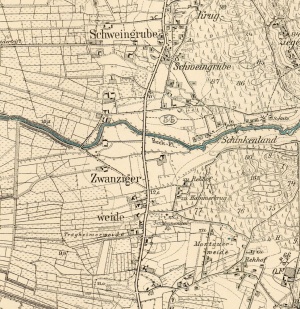
| − | + | [[File:SchweingrubeTragheimerweideZwanzigerweide.jpg|300px|thumb|right|''Detailed map of Schweingrube, 1913. | |
Source: [http://amzpbig.com/maps/2179_Rehhof_1913.jpg Archiwum Map Zachodniej Polski] Archiwum Map Zachodniej Polski | Source: [http://amzpbig.com/maps/2179_Rehhof_1913.jpg Archiwum Map Zachodniej Polski] Archiwum Map Zachodniej Polski | ||
| Line 12: | Line 12: | ||
Mennonites who were residents of Schweingrube were members of the Tragheimerweide Mennonite Church. | Mennonites who were residents of Schweingrube were members of the Tragheimerweide Mennonite Church. | ||
| − | |||
| − | |||
= Bibliography = | = Bibliography = | ||
"Familienforschung in Westpreußen." Hans-Jürgen Wolf. Web. 29 September 2012. [http://www.westpreussen.de/cms/ct/ortsverzeichnis/details.php http://www.westpreussen.de]. | "Familienforschung in Westpreußen." Hans-Jürgen Wolf. Web. 29 September 2012. [http://www.westpreussen.de/cms/ct/ortsverzeichnis/details.php http://www.westpreussen.de]. | ||
Stowarzyszenie Konserwatorów Zabytków. "Stara Koscielnica." Catalogue of Monuments of Dutch Colonization in Poland. 2005. Web. 6 April 2013. [http://holland.org.pl/art.php http://holland.org.pl/art.php?kat=obiekt&id=504&lang=en]. | Stowarzyszenie Konserwatorów Zabytków. "Stara Koscielnica." Catalogue of Monuments of Dutch Colonization in Poland. 2005. Web. 6 April 2013. [http://holland.org.pl/art.php http://holland.org.pl/art.php?kat=obiekt&id=504&lang=en]. | ||
| − | |||
| − | |||
= Maps = | = Maps = | ||
[[Map:Szwedy (Pomeranian Voivodeship, Poland)|Map:Szwedy (Pomeranian Voivodeship, Poland)]] | [[Map:Szwedy (Pomeranian Voivodeship, Poland)|Map:Szwedy (Pomeranian Voivodeship, Poland)]] | ||
{{GAMEO_footer|hp=Vol. 4, p. 487|date=April 2013|a1_last=van der Zijpp|a1_first=Nanne|a2_last=Thiessen|a2_first=Richard D.}} | {{GAMEO_footer|hp=Vol. 4, p. 487|date=April 2013|a1_last=van der Zijpp|a1_first=Nanne|a2_last=Thiessen|a2_first=Richard D.}} | ||
Revision as of 18:59, 20 August 2013

Schweingrube (also known as Swiniagrupa, Świnia Grupa, Schweingruppe, and Schweinegrube, now known as Szwedy; coordinates: 53.8754702, 18.9391284 [53° 52′ 31″ N, 18° 56′ 20″ E]; population in 1905, 229), located approximately 16 kilometers (10 miles) north of Kwidzyn (Marienwerder), 19 km. (12 miles) south-west of Malbork (Marienburg), and 26 km (16 miles) south-east of Tczew (Dirschau). The village was located in the district of Stuhm (Sztum) in West Prussia (now Poland), the seat of a Waterlander Mennonite congregation, formerly also called Stühmsche Niederung, later Tragheimerweide.
The First Partition of Poland in 1772 resulted in the creation of a new province in 1773, called West Prussia, in which Tragheimerweide was located. Tragheimerweide was situated in the district (Kreis) of Stuhm until the end of World War I, when it came under the jurisdiction of the German province of East Prussia. In 1928 the villages of Tragheimerweide, Zwanzigerweide, and Schweingrube were combined into one political unit. The village came under the control of Nazi Germany during World War II until February 1945, when it was occupied by Soviet forces and returned to Poland.
In 1740, Michał Bieliński, the Starost of Sztum, granted 84 hectares of land to Mennonites. In 1758, Tekla Bielińska leased some of the land for 30 years to the following settlers: Heinrich Nickel, Gils Ewert and Hans and Henrich Ewarts. In 1770, Franciszek Bieliński renewed the 1740 contract for the next 30 years with the following settlers: Hans Markwart, Abraham Zels, Henrich Pauls, Peter Peters, Franz Gerz, and Abraham Penner.
The 1776 Prussian census lists 14 Mennonite families in Schweingrube with the following surnames: Aderian, Bartel, Ediger, Ewert, Flemming, Goert(z), Jantzen, Nickel, and Pauls.
Mennonites who were residents of Schweingrube were members of the Tragheimerweide Mennonite Church.
Bibliography
"Familienforschung in Westpreußen." Hans-Jürgen Wolf. Web. 29 September 2012. http://www.westpreussen.de.
Stowarzyszenie Konserwatorów Zabytków. "Stara Koscielnica." Catalogue of Monuments of Dutch Colonization in Poland. 2005. Web. 6 April 2013. http://holland.org.pl/art.php?kat=obiekt&id=504&lang=en.
Maps
Map:Szwedy (Pomeranian Voivodeship, Poland)
| Author(s) | Nanne van der Zijpp |
|---|---|
| Richard D. Thiessen | |
| Date Published | April 2013 |
Cite This Article
MLA style
van der Zijpp, Nanne and Richard D. Thiessen. "Schweingrube (Pomeranian Voivodeship, Poland)." Global Anabaptist Mennonite Encyclopedia Online. April 2013. Web. 3 Feb 2026. https://gameo.org/index.php?title=Schweingrube_(Pomeranian_Voivodeship,_Poland)&oldid=77677.
APA style
van der Zijpp, Nanne and Richard D. Thiessen. (April 2013). Schweingrube (Pomeranian Voivodeship, Poland). Global Anabaptist Mennonite Encyclopedia Online. Retrieved 3 February 2026, from https://gameo.org/index.php?title=Schweingrube_(Pomeranian_Voivodeship,_Poland)&oldid=77677.
Adapted by permission of Herald Press, Harrisonburg, Virginia, from Mennonite Encyclopedia, Vol. 4, p. 487. All rights reserved.
©1996-2026 by the Global Anabaptist Mennonite Encyclopedia Online. All rights reserved.
