Difference between revisions of "Stüblau (Pomeranian Voivodeship, Poland)"
| [checked revision] | [checked revision] |
m |
AlfRedekopp (talk | contribs) m (Text replacement - "cms/ct/" to "pages/forschungshilfen/") |
||
| (2 intermediate revisions by one other user not shown) | |||
| Line 1: | Line 1: | ||
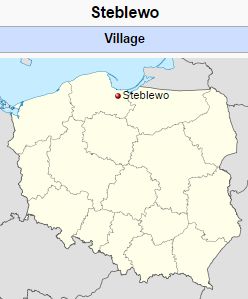
| − | [[File:Steblewo.jpg|300px|thumb|right|''Source: [http://commons.wikimedia.org/wiki/Main_Page Wikipedia Commons]'']] | + | [[File:Steblewo.jpg|300px|thumb|right|''Stüblau (now Steblewo, Poland).<br /> |
| + | Source: [http://commons.wikimedia.org/wiki/Main_Page Wikipedia Commons]'']] | ||
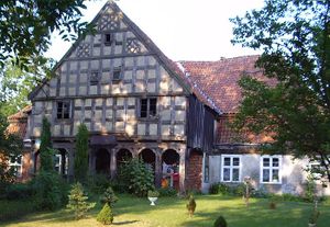
| + | [[File:SteblewoHouse.jpg|300px|thumbnail|left|''House in Stüblau (now Steblewo, Poland.<br /> | ||
| + | Source: [http://www.ordensland.de/Landguter/landguter.html Vorlaubenhäuser im Weichselwerder, Das Land Des Deutschen Orden: Ostpreussen-Westpreussen-Memelland]''.]] | ||
Stüblau (also known as Stubelow; now known as Steblewo; coordinates: 54.17988, 18.82974 [54° 10′ 47″ N, 18° 49′ 47″ E]; population in 1905, 451; in 2014, 410) is located 9.1 kilometers (km) (5.7 miles) north north-east of Tczew ([[Dirschau (Pomeranian Voivodeship, Poland)|Dirschau]]), 16.0 km (10 miles) south-east of Pruszcz Gdański (Praust), 19.1 km (11.9 miles) west south-west of Nowy Dwór Gdański ([[Tiegenhof (Pomeranian Voivodeship, Poland)|Tiegenhof]]), and 21.7 km (13.5 miles) northwest of Malbork ([[Marienburg (Pomeranian Voivodeship, Poland)|Marienburg]]). | Stüblau (also known as Stubelow; now known as Steblewo; coordinates: 54.17988, 18.82974 [54° 10′ 47″ N, 18° 49′ 47″ E]; population in 1905, 451; in 2014, 410) is located 9.1 kilometers (km) (5.7 miles) north north-east of Tczew ([[Dirschau (Pomeranian Voivodeship, Poland)|Dirschau]]), 16.0 km (10 miles) south-east of Pruszcz Gdański (Praust), 19.1 km (11.9 miles) west south-west of Nowy Dwór Gdański ([[Tiegenhof (Pomeranian Voivodeship, Poland)|Tiegenhof]]), and 21.7 km (13.5 miles) northwest of Malbork ([[Marienburg (Pomeranian Voivodeship, Poland)|Marienburg]]). | ||
| Line 10: | Line 13: | ||
Wikipedia. "Steblewo." 1 April 2014. Web. 14 September 2014. https://en.wikipedia.org/wiki/Steblewo. | Wikipedia. "Steblewo." 1 April 2014. Web. 14 September 2014. https://en.wikipedia.org/wiki/Steblewo. | ||
| − | Wolf, Hans-Jürgen. "Familienforschung in Westpreußen." Web. 14 September 2014. http://www.westpreussen.de/ | + | Wolf, Hans-Jürgen. "Familienforschung in Westpreußen." Web. 14 September 2014. http://www.westpreussen.de/pages/forschungshilfen/ortsverzeichnis/details.php?ID=6384. |
= Maps = | = Maps = | ||
[[Map:Stüblau (Pomeranian Voivodeship, Poland)|Map:Stüblau (Pomeranian Voivodeship, Poland)]] | [[Map:Stüblau (Pomeranian Voivodeship, Poland)|Map:Stüblau (Pomeranian Voivodeship, Poland)]] | ||
Latest revision as of 16:45, 23 June 2020

Source: Vorlaubenhäuser im Weichselwerder, Das Land Des Deutschen Orden: Ostpreussen-Westpreussen-Memelland.
Stüblau (also known as Stubelow; now known as Steblewo; coordinates: 54.17988, 18.82974 [54° 10′ 47″ N, 18° 49′ 47″ E]; population in 1905, 451; in 2014, 410) is located 9.1 kilometers (km) (5.7 miles) north north-east of Tczew (Dirschau), 16.0 km (10 miles) south-east of Pruszcz Gdański (Praust), 19.1 km (11.9 miles) west south-west of Nowy Dwór Gdański (Tiegenhof), and 21.7 km (13.5 miles) northwest of Malbork (Marienburg).
Until 1793 Stüblau was part of Danzig in Royal Prussia (also known as Polish Prussia) in the Kingdom of Poland. The Second Partition of Poland in 1793 added Danzig and its surrounding territory to the province of West Prussia. The village was situated in the district (Kreis) of Danzig from 1818 until 1887, when it became part of the district of Dirschau. Stüblau became part of the Free City of Danzig from 1920 until the outbreak of World War II in 1939, when it came under the control of Nazi Germany. In February 1945 it was occupied by Soviet forces and eventually returned to Poland. In 2014 it was a village in the administrative district of Gmina Suchy Dąb, within Gdańsk County, Pomeranian Voivodeship, in northern Poland.
Here Dutch Mennonites settled at a very early period (ca. 1543) to drain this swampy area. No Mennonites were listed as living in Stüblau in the 1793 or 1820 census lists for the region.
Bibliography
Penner, Horst. Ansiedlung mennonitischer Niederländer im Weichselmündungsgebiet. Weierhof, 1940: 10, 17 f., 19.
Wikipedia. "Steblewo." 1 April 2014. Web. 14 September 2014. https://en.wikipedia.org/wiki/Steblewo.
Wolf, Hans-Jürgen. "Familienforschung in Westpreußen." Web. 14 September 2014. http://www.westpreussen.de/pages/forschungshilfen/ortsverzeichnis/details.php?ID=6384.
Maps
Map:Stüblau (Pomeranian Voivodeship, Poland)
| Author(s) | Nanne van der Zijpp |
|---|---|
| Date Published | 1959 |
Cite This Article
MLA style
Zijpp, Nanne van der. "Stüblau (Pomeranian Voivodeship, Poland)." Global Anabaptist Mennonite Encyclopedia Online. 1959. Web. 19 Jan 2026. https://gameo.org/index.php?title=St%C3%BCblau_(Pomeranian_Voivodeship,_Poland)&oldid=168676.
APA style
Zijpp, Nanne van der. (1959). Stüblau (Pomeranian Voivodeship, Poland). Global Anabaptist Mennonite Encyclopedia Online. Retrieved 19 January 2026, from https://gameo.org/index.php?title=St%C3%BCblau_(Pomeranian_Voivodeship,_Poland)&oldid=168676.
Adapted by permission of Herald Press, Harrisonburg, Virginia, from Mennonite Encyclopedia, Vol. 4, p. 646. All rights reserved.
©1996-2026 by the Global Anabaptist Mennonite Encyclopedia Online. All rights reserved.

