Difference between revisions of "Christfelde (Kuyavian-Pomeranian Voivodeship, Poland)"
| [checked revision] | [checked revision] |
GameoAdmin (talk | contribs) (CSV import - 20130823) |
AlfRedekopp (talk | contribs) m (Text replacement - "cms/ct/" to "pages/forschungshilfen/") |
||
| (4 intermediate revisions by one other user not shown) | |||
| Line 1: | Line 1: | ||
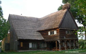
| − | [[File:Christfelde.jpg|300px|thumb|right|''Christfelde (now Chrystkowo, Poland) | + | [[File:Christfelde.jpg|300px|thumb|right|''Christfelde (now Chrystkowo, Poland)<br /> |
| − | + | Source: [http://en.wikipedia.org/wiki/Chrystkowo Wikipedia Commons]'']] | |
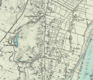
| − | Source: [http://en.wikipedia.org/wiki/Chrystkowo Wikipedia Commons]'']] | + | [[File:Christfelde%201913.jpg|300px|thumb|left|''Christfelde in 1913.<br /> |
| − | + | Source: [http://amzpbig.com/maps/2675_Grutschno_1913.jpg Archiwum Map Zachodniej Polski]'']] | |
| − | Source: [http://amzpbig.com/maps/2675_Grutschno_1913.jpg Archiwum Map Zachodniej Polski]'']] | + | [[File:Chrystkowo 1.jpg|300px|thumbnail|right|''House built by Mennonites in Chrystkowo, Poland.<br /> |
| + | Source: [http://www.ordensland.de/Landguter/landguter.html Vorlaubenhäuser im Weichselwerder, Das Land Des Deutschen Orden: Ostpreussen-Westpreussen-Memelland]''.]] | ||
| + | Christfelde (also known as Kepa Krysktkowska, Kristkovo, Krostkowo, and Krystkowo; now known as Chrystkowo; coordinates: 53.325747, 18.318672 [53° 19′ 32″ N, 18° 19′ 7″ E]; population in 1905, 204; in 2013, 170) is located approximately 8 kilometers (5 miles) south-west of Chełmno (Kulm), 13 km. (8 miles) south-west of Świecie (Schwetz), and 39 km. (24 miles) north-west of Toruń ([[Thorn (Kuyavian-Pomeranian Voivodeship, Poland)|Thorn]]). | ||
The village and the neighboring hamlet of Kosowo, situated in the Polish territory of Schwetz (Świecie) near the left bank of the Vistula River, were in the 17th and 18<sup>th</sup> centuries occupied by Mennonite farmers of Dutch descent. In 1650 the Mennonites of Christfelde and Kosowo obtained a charter of protection granted them by King[[John II Casimir, King of Poland (1609-1672)| Johann II Casimir]] of [[Poland|Poland]]. They were granted freedom of religion and the privilege of choosing their own [[Schulze |Schulze ]](magistrate) and conducting their own schools. They also had an economic privilege, permitting them to transport their grain without paying taxes to [[Danzig (Poland)|Danzig]], in order to sell it there. A congregation in Christfelde is not known; these Mennonites may have belonged to a congregation in a neighboring town. | The village and the neighboring hamlet of Kosowo, situated in the Polish territory of Schwetz (Świecie) near the left bank of the Vistula River, were in the 17th and 18<sup>th</sup> centuries occupied by Mennonite farmers of Dutch descent. In 1650 the Mennonites of Christfelde and Kosowo obtained a charter of protection granted them by King[[John II Casimir, King of Poland (1609-1672)| Johann II Casimir]] of [[Poland|Poland]]. They were granted freedom of religion and the privilege of choosing their own [[Schulze |Schulze ]](magistrate) and conducting their own schools. They also had an economic privilege, permitting them to transport their grain without paying taxes to [[Danzig (Poland)|Danzig]], in order to sell it there. A congregation in Christfelde is not known; these Mennonites may have belonged to a congregation in a neighboring town. | ||
| Line 13: | Line 15: | ||
See [[Przechovka (Kuyavian-Pomeranian Voivodeship, Poland)|Przechovka]]. | See [[Przechovka (Kuyavian-Pomeranian Voivodeship, Poland)|Przechovka]]. | ||
= Bibliography = | = Bibliography = | ||
| − | "Familienforschung in Westpreußen." Hans-Jürgen Wolf. Web. 29 September 2012. [http://www.westpreussen.de/ | + | "Familienforschung in Westpreußen." Hans-Jürgen Wolf. Web. 29 September 2012. [http://www.westpreussen.de/pages/forschungshilfen/ortsverzeichnis/details.php http://www.westpreussen.de]. |
Szper, Felicia. <em>Nederlandsche nederzettingen in West-Pruisen gedurende den Poolschen tijd. </em>Enkhuizen: Bais, 1913: 143 f. | Szper, Felicia. <em>Nederlandsche nederzettingen in West-Pruisen gedurende den Poolschen tijd. </em>Enkhuizen: Bais, 1913: 143 f. | ||
| Line 21: | Line 23: | ||
= Maps = | = Maps = | ||
[[Map:Chrystkowo (Kuyavian-Pomeranian Voivodeship, Poland)|Map:Chrystkowo (Kuyavian-Pomeranian Voivodeship, Poland)]] | [[Map:Chrystkowo (Kuyavian-Pomeranian Voivodeship, Poland)|Map:Chrystkowo (Kuyavian-Pomeranian Voivodeship, Poland)]] | ||
| − | {{GAMEO_footer|hp=Vol. 3, p. 245|date=March 2013|a1_last= | + | {{GAMEO_footer|hp=Vol. 3, p. 245|date=March 2013|a1_last=Zijpp|a1_first=Nanne van der|a2_last=Thiessen|a2_first=Richard D.}} |
| + | [[Category:Cities, Towns, and Villages]] | ||
| + | [[Category:Cities, Towns, and Villages in Poland]] | ||
Latest revision as of 15:56, 23 June 2020

Source: Vorlaubenhäuser im Weichselwerder, Das Land Des Deutschen Orden: Ostpreussen-Westpreussen-Memelland.
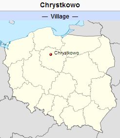
Christfelde (also known as Kepa Krysktkowska, Kristkovo, Krostkowo, and Krystkowo; now known as Chrystkowo; coordinates: 53.325747, 18.318672 [53° 19′ 32″ N, 18° 19′ 7″ E]; population in 1905, 204; in 2013, 170) is located approximately 8 kilometers (5 miles) south-west of Chełmno (Kulm), 13 km. (8 miles) south-west of Świecie (Schwetz), and 39 km. (24 miles) north-west of Toruń (Thorn).
The village and the neighboring hamlet of Kosowo, situated in the Polish territory of Schwetz (Świecie) near the left bank of the Vistula River, were in the 17th and 18th centuries occupied by Mennonite farmers of Dutch descent. In 1650 the Mennonites of Christfelde and Kosowo obtained a charter of protection granted them by King Johann II Casimir of Poland. They were granted freedom of religion and the privilege of choosing their own Schulze (magistrate) and conducting their own schools. They also had an economic privilege, permitting them to transport their grain without paying taxes to Danzig, in order to sell it there. A congregation in Christfelde is not known; these Mennonites may have belonged to a congregation in a neighboring town.
Until 1772 Christfelde was located in what was known as Royal Prussia (also known as Polish Prussia) in the Kingdom of Poland. The First Partition of Poland in 1772 resulted in the creation of a new province on 31 January 1773, called West Prussia, in which Christfelde was located. Christfelde was situated in the district (Kreis) of Schwetz in Regierungsbezirk Marienwerder until the end of World War I, when it came under the jurisdiction of the Pomeranian Voivodeship of the Second Polish Republic. The village came under the control of Nazi Germany during World War II until March 1945, when it was occupied by Soviet forces and returned to Poland. In 2013 Chrystkowo was a village in the administrative district of Gmina Świecie, within Świecie County, Kuyavian-Pomeranian Voivodeship.
The following surnames are listed in a lease document for Christfelde from 1664: Bartel, Buller, Nachtigal, and Stobe. In 1676 the following surnames are listed in a least document for Christfelde and Kossowo: Block, Commsen, Evertsen, Kopper, Leucke, and Tyartz. There are no Mennonites listed in Christfelde in the Prussian 1776 census.
See Przechovka.
Bibliography
"Familienforschung in Westpreußen." Hans-Jürgen Wolf. Web. 29 September 2012. http://www.westpreussen.de.
Szper, Felicia. Nederlandsche nederzettingen in West-Pruisen gedurende den Poolschen tijd. Enkhuizen: Bais, 1913: 143 f.
Wikipedia. "Chrystkowo." Web. 3 October 2012. http://en.wikipedia.org/wiki/Chrystkowo.
Maps
Map:Chrystkowo (Kuyavian-Pomeranian Voivodeship, Poland)
| Author(s) | Nanne van der Zijpp |
|---|---|
| Richard D. Thiessen | |
| Date Published | March 2013 |
Cite This Article
MLA style
Zijpp, Nanne van der and Richard D. Thiessen. "Christfelde (Kuyavian-Pomeranian Voivodeship, Poland)." Global Anabaptist Mennonite Encyclopedia Online. March 2013. Web. 24 Nov 2024. https://gameo.org/index.php?title=Christfelde_(Kuyavian-Pomeranian_Voivodeship,_Poland)&oldid=168578.
APA style
Zijpp, Nanne van der and Richard D. Thiessen. (March 2013). Christfelde (Kuyavian-Pomeranian Voivodeship, Poland). Global Anabaptist Mennonite Encyclopedia Online. Retrieved 24 November 2024, from https://gameo.org/index.php?title=Christfelde_(Kuyavian-Pomeranian_Voivodeship,_Poland)&oldid=168578.
Adapted by permission of Herald Press, Harrisonburg, Virginia, from Mennonite Encyclopedia, Vol. 3, p. 245. All rights reserved.
©1996-2024 by the Global Anabaptist Mennonite Encyclopedia Online. All rights reserved.


