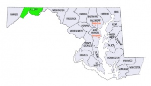
Allegany County (Maryland, USA)
Allegany County lies in the mountainous western neck of Maryland. Formed from Washington County in 1776, it originally included the present Garrett County, which lies to the west. Garrett County was formed from Allegany County in 1872.
As early as 1800 Amish settlers were settled on lands in the present area of Garrett County and Mennonites followed in later years. (See Somerset County, Pennsylvania and Garrett County, Maryland.)
A Mennonite congregation, member of the Southwestern Pennsylvania Mennonite Conference (MC), was located at Pinto, a village eight miles (13 km) southwest of Cumberland. This congregation, extending into Mineral County, West Virginia, was organized 27 November 1927.
A mission outpost was maintained at Flintstone, a village twelve miles (20 km) east of Cumberland, by the Mennonite churches of Washington County.
| Author(s) | Ivan J Miller |
|---|---|
| Date Published | 1955 |
Cite This Article
MLA style
Miller, Ivan J. "Allegany County (Maryland, USA)." Global Anabaptist Mennonite Encyclopedia Online. 1955. Web. 12 Feb 2026. https://gameo.org/index.php?title=Allegany_County_(Maryland,_USA)&oldid=74652.
APA style
Miller, Ivan J. (1955). Allegany County (Maryland, USA). Global Anabaptist Mennonite Encyclopedia Online. Retrieved 12 February 2026, from https://gameo.org/index.php?title=Allegany_County_(Maryland,_USA)&oldid=74652.
Adapted by permission of Herald Press, Harrisonburg, Virginia, from Mennonite Encyclopedia, Vol. 1, p. 55. All rights reserved.
©1996-2026 by the Global Anabaptist Mennonite Encyclopedia Online. All rights reserved.

