Adamsdorf (Kuyavian-Pomeranian Voivodeship, Poland)


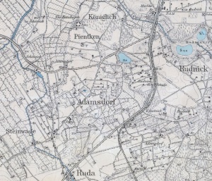
Adamsdorf (also known as Rude, Ruden, Rauden, Rawden, Königlich Ruda, Adamowo, and Jadamowo; now known as Mały Rudnik; coordinates: 53.40595, 18.721733 [53° 24′ 21″ N, 18° 43′ 18″ E]; population in 1905, 427) is located approximately 9 kilometers (5.5 miles) south-west of Grudziądz (Graudenz), 18 km. (11 miles) east of Świecie (Schwetz), and 20 km. (12 miles) north-east of Chełmno (Culm).
Until 1772 Adamsdorf was located in what was known as Royal Prussia (also known as Polish Prussia) in the Kingdom of Poland. The First Partition of Poland in 1772 resulted in the creation of a new province on 31 January 1773, called West Prussia, in which Adamsdorf was located. Adamsdorf was situated in the district (Kreis) of Graudenz in Regierungsbezirk Marienwerder until the end of World War I, when it came under the jurisdiction of the Pomeranian Voivodeship of the Second Polish Republic. Adamsdorf came under the control of Nazi Germany during World War II until March 1945, when it was occupied by Soviet forces and returned to Poland. In 2013 Mały Rudnik was a village in the administrative district of Gmina Grudziądz, within Grudziądz County, Kuyavian-Pomeranian Voivodeship.
The 1824 Marienwerder census lists two Mennonite families in Adamsdorf, named Eggert and Dirks. The Eckert (Eggert) family immigrated to Russia in 1827.
Mennonites who were residents of Adamsdorf were members of the Schönsee Mennonite Church.
Bibliography
Wikipedia. "Mały Rudnik." Web. 29 March 2013. http://en.wikipedia.org/wiki/Mały_Rudnik.
Wolf, Hans-Jürgen. "Familienforschung in Westpreußen." Web. 29 March 2013. http://www.westpreussen.de/cms/ct/ortsverzeichnis/details.php?ID=16.
Maps
Map:Mały Rudnik, Kuyavian-Pomeranian Voivodeship, Poland
| Author(s) | Richard D Thiessen |
|---|---|
| Date Published | March 2013 |
Cite This Article
MLA style
Thiessen, Richard D. "Adamsdorf (Kuyavian-Pomeranian Voivodeship, Poland)." Global Anabaptist Mennonite Encyclopedia Online. March 2013. Web. 1 Feb 2026. https://gameo.org/index.php?title=Adamsdorf_(Kuyavian-Pomeranian_Voivodeship,_Poland)&oldid=62340.
APA style
Thiessen, Richard D. (March 2013). Adamsdorf (Kuyavian-Pomeranian Voivodeship, Poland). Global Anabaptist Mennonite Encyclopedia Online. Retrieved 1 February 2026, from https://gameo.org/index.php?title=Adamsdorf_(Kuyavian-Pomeranian_Voivodeship,_Poland)&oldid=62340.
©1996-2026 by the Global Anabaptist Mennonite Encyclopedia Online. All rights reserved.