Difference between revisions of "Stüblau (Pomeranian Voivodeship, Poland)"
| [checked revision] | [checked revision] |
GameoAdmin (talk | contribs) (CSV import - 20130823) |
m (Text replace - "date=1959|a1_last=van der Zijpp|a1_first=Nanne" to "date=1959|a1_last=Zijpp|a1_first=Nanne van der") |
||
| Line 5: | Line 5: | ||
= Maps = | = Maps = | ||
[[Map:Stüblau (Pomeranian Voivodeship, Poland)|Map:Stüblau (Pomeranian Voivodeship, Poland)]] | [[Map:Stüblau (Pomeranian Voivodeship, Poland)|Map:Stüblau (Pomeranian Voivodeship, Poland)]] | ||
| − | {{GAMEO_footer|hp=Vol. 4, p. 646|date=1959|a1_last= | + | {{GAMEO_footer|hp=Vol. 4, p. 646|date=1959|a1_last=Zijpp|a1_first=Nanne van der|a2_last=|a2_first=}} |
Revision as of 16:01, 20 January 2014

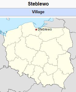
Stüblau, northern part of the Danzig Werder in West Prussia, Germany, now known as Steblewo in the Pomeranian Voivodeship of Poland (coordinates: 54° 10' 37 N, 18° 49' 47 E). Here Dutch Mennonites settled at a very early period (ca. 1543) to drain this swampy area.
Bibliography
Penner, Horst. Ansiedlung mennonitischer Niederländer im Weichselmündungsgebiet. Weierhof, 1940: 10, 17 f., 19.
Maps
Map:Stüblau (Pomeranian Voivodeship, Poland)
| Author(s) | Nanne van der Zijpp |
|---|---|
| Date Published | 1959 |
Cite This Article
MLA style
Zijpp, Nanne van der. "Stüblau (Pomeranian Voivodeship, Poland)." Global Anabaptist Mennonite Encyclopedia Online. 1959. Web. 24 Nov 2024. https://gameo.org/index.php?title=St%C3%BCblau_(Pomeranian_Voivodeship,_Poland)&oldid=109519.
APA style
Zijpp, Nanne van der. (1959). Stüblau (Pomeranian Voivodeship, Poland). Global Anabaptist Mennonite Encyclopedia Online. Retrieved 24 November 2024, from https://gameo.org/index.php?title=St%C3%BCblau_(Pomeranian_Voivodeship,_Poland)&oldid=109519.
Adapted by permission of Herald Press, Harrisonburg, Virginia, from Mennonite Encyclopedia, Vol. 4, p. 646. All rights reserved.
©1996-2024 by the Global Anabaptist Mennonite Encyclopedia Online. All rights reserved.
