Difference between revisions of "Fischerskampe (Warmian-Masurian Voivodeship, Poland)"
| [unchecked revision] | [checked revision] |
GameoAdmin (talk | contribs) (CSV import - 20130816) |
AlfRedekopp (talk | contribs) |
||
| (3 intermediate revisions by 2 users not shown) | |||
| Line 1: | Line 1: | ||
| − | + | [[File:Fischerskampe.jpg|300px|thumb|right|''Fischerskampe (now Kępa Rybacka, Poland).<br /> | |
| − | + | Source: [http://en.wikipedia.org/wiki/K%C4%99pa_Rybacka Wikipedia Commons]'']] | |
| − | Source: [http://en.wikipedia.org/wiki/K%C4%99pa_Rybacka Wikipedia Commons] | + | Fischerskampe (also known as Müggenkampe, Fischers Campe, Fischercampe, and Fischer Wohnungen; now known as Kępa Rybacka; coordinates: 54.213, 19.325 [54° 12′ 46″ N, 19° 19′ 29″ E]; population in 1905, 379; in 2013, 140) is located 6 kilometers (4 miles) north-west of Elblag ([[Elbing (Warmian-Masurian Voivodeship, Poland)|Elbing]]), 14 km. (8 mi.) east of Nowy Dwór Gdański (Tiegenhof), 27 km. (17 mi.) north-east of Malbork (Marienburg). |
| − | |||
| − | '']] | ||
The first attempt (mid 1600s) to settle Mennonites in Fischerskampe in the mid-17th century was unsuccesful. In 1683, the area was leased to Otto Ulbitz and then to Ernest Fisher. The village was re-founded in 1691. In 1715, it had 8 włókas and 21.5 morgas (157 hectares). Fischerskampe was destroyed by flooding in both 1763 and 1764. In 1919, the village had 358 ha. of land and 322 residents. | The first attempt (mid 1600s) to settle Mennonites in Fischerskampe in the mid-17th century was unsuccesful. In 1683, the area was leased to Otto Ulbitz and then to Ernest Fisher. The village was re-founded in 1691. In 1715, it had 8 włókas and 21.5 morgas (157 hectares). Fischerskampe was destroyed by flooding in both 1763 and 1764. In 1919, the village had 358 ha. of land and 322 residents. | ||
| Line 12: | Line 10: | ||
Mennonites who were residents of Fischerskampe were members of the Elbing-Ellerwald Mennonite Church. | Mennonites who were residents of Fischerskampe were members of the Elbing-Ellerwald Mennonite Church. | ||
| − | |||
| − | |||
= Bibliography = | = Bibliography = | ||
Stowarzyszenie Konserwatorów Zabytków. "Kępa Rybacka." Catalogue of Monuments of Dutch Colonization in Poland. 2005. Web. 3 February 2013. [http://holland.org.pl/art.php http://holland.org.pl/art.php?kat=obiekt&id=350&lang=en]. | Stowarzyszenie Konserwatorów Zabytków. "Kępa Rybacka." Catalogue of Monuments of Dutch Colonization in Poland. 2005. Web. 3 February 2013. [http://holland.org.pl/art.php http://holland.org.pl/art.php?kat=obiekt&id=350&lang=en]. | ||
| Line 19: | Line 15: | ||
Wikipedia. "Kępa Rybacka." Web. 3 February 2013. [http://en.wikipedia.org/wiki/Kępa_Rybacka http://en.wikipedia.org/wiki/Kępa_Rybacka]. | Wikipedia. "Kępa Rybacka." Web. 3 February 2013. [http://en.wikipedia.org/wiki/Kępa_Rybacka http://en.wikipedia.org/wiki/Kępa_Rybacka]. | ||
| − | Wolf, Hans-Jürgen. "Familienforschung in Westpreußen." Web. | + | Wolf, Hans-Jürgen. "Familienforschung in Westpreußen." Web. 23 June 2020. [http://www.westpreussen.de/pages/forschungshilfen/ortsverzeichnis/details.php?ID=1546 http://www.westpreussen.de/pages/forschungshilfen/ortsverzeichnis/details.php]. |
| − | |||
| − | |||
= Maps = | = Maps = | ||
[[Map:Kępa Rybacka, Warmian-Masurian Voivodeship|Map:Kępa Rybacka, Warmian-Masurian Voivodeship]] | [[Map:Kępa Rybacka, Warmian-Masurian Voivodeship|Map:Kępa Rybacka, Warmian-Masurian Voivodeship]] | ||
{{GAMEO_footer|hp=|date=February 2013|a1_last=Thiessen|a1_first=Richard D|a2_last=|a2_first=}} | {{GAMEO_footer|hp=|date=February 2013|a1_last=Thiessen|a1_first=Richard D|a2_last=|a2_first=}} | ||
| + | [[Category:Places]] | ||
| + | [[Category:Cities, Towns, and Villages]] | ||
| + | [[Category:Cities, Towns, and Villages in Poland]] | ||
Latest revision as of 14:46, 23 June 2020
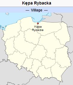
Fischerskampe (also known as Müggenkampe, Fischers Campe, Fischercampe, and Fischer Wohnungen; now known as Kępa Rybacka; coordinates: 54.213, 19.325 [54° 12′ 46″ N, 19° 19′ 29″ E]; population in 1905, 379; in 2013, 140) is located 6 kilometers (4 miles) north-west of Elblag (Elbing), 14 km. (8 mi.) east of Nowy Dwór Gdański (Tiegenhof), 27 km. (17 mi.) north-east of Malbork (Marienburg).
The first attempt (mid 1600s) to settle Mennonites in Fischerskampe in the mid-17th century was unsuccesful. In 1683, the area was leased to Otto Ulbitz and then to Ernest Fisher. The village was re-founded in 1691. In 1715, it had 8 włókas and 21.5 morgas (157 hectares). Fischerskampe was destroyed by flooding in both 1763 and 1764. In 1919, the village had 358 ha. of land and 322 residents.
Until 1772 Fischerskampe was located in what was known as Royal Prussia (also known as Polish Prussia) in the Kingdom of Poland. The First Partition of Poland in 1772 resulted in the creation of a new province in 1773, called West Prussia, in which the village was located. Fischerskampe was situated in the district (Kreis) of Elbing until the end of World War I, when it came under the jurisdiction of the German province of East Prussia. In 2013 it was a village in the administrative district of Gmina Elbląg, within Elbląg County, Warmian-Masurian Voivodeship.
Mennonites probably moved to Fischerskampe at the beginning of the 19th century. In the 1811 Elbing region census, no Mennonites were recorded as living in Fischerskampe. In 1820, there were 271 inhabitants in Fischerskampe, of which seven were Mennonite.
Mennonites who were residents of Fischerskampe were members of the Elbing-Ellerwald Mennonite Church.
Bibliography
Stowarzyszenie Konserwatorów Zabytków. "Kępa Rybacka." Catalogue of Monuments of Dutch Colonization in Poland. 2005. Web. 3 February 2013. http://holland.org.pl/art.php?kat=obiekt&id=350&lang=en.
Wikipedia. "Kępa Rybacka." Web. 3 February 2013. http://en.wikipedia.org/wiki/Kępa_Rybacka.
Wolf, Hans-Jürgen. "Familienforschung in Westpreußen." Web. 23 June 2020. http://www.westpreussen.de/pages/forschungshilfen/ortsverzeichnis/details.php.
Maps
Map:Kępa Rybacka, Warmian-Masurian Voivodeship
| Author(s) | Richard D Thiessen |
|---|---|
| Date Published | February 2013 |
Cite This Article
MLA style
Thiessen, Richard D. "Fischerskampe (Warmian-Masurian Voivodeship, Poland)." Global Anabaptist Mennonite Encyclopedia Online. February 2013. Web. 23 Nov 2024. https://gameo.org/index.php?title=Fischerskampe_(Warmian-Masurian_Voivodeship,_Poland)&oldid=168550.
APA style
Thiessen, Richard D. (February 2013). Fischerskampe (Warmian-Masurian Voivodeship, Poland). Global Anabaptist Mennonite Encyclopedia Online. Retrieved 23 November 2024, from https://gameo.org/index.php?title=Fischerskampe_(Warmian-Masurian_Voivodeship,_Poland)&oldid=168550.
©1996-2024 by the Global Anabaptist Mennonite Encyclopedia Online. All rights reserved.
