Difference between revisions of "Schönbaum (Pomeranian Voivodeship, Poland)"
| [checked revision] | [checked revision] |
AlfRedekopp (talk | contribs) m (Text replacement - "cms/ct/" to "pages/forschungshilfen/") |
AlfRedekopp (talk | contribs) |
||
| Line 19: | Line 19: | ||
Wikipedia. "Drewnica, Nowy Dwór Gdański County." Web. 30 November 2012. [http://en.wikipedia.org/wiki/Drewnica,_Nowy_Dw%C3%B3r_Gda%C5%84ski_County http://en.wikipedia.org/wiki/Drewnica,_Nowy_Dw%C3%B3r_Gda%C5%84ski_County]. | Wikipedia. "Drewnica, Nowy Dwór Gdański County." Web. 30 November 2012. [http://en.wikipedia.org/wiki/Drewnica,_Nowy_Dw%C3%B3r_Gda%C5%84ski_County http://en.wikipedia.org/wiki/Drewnica,_Nowy_Dw%C3%B3r_Gda%C5%84ski_County]. | ||
| − | Wolf, Hans-Jürgen. "Familienforschung in Westpreußen." Web. | + | Wolf, Hans-Jürgen. "Familienforschung in Westpreußen." Web. 23 June 2020. [http://www.westpreussen.de/pages/forschungshilfen/ortsverzeichnis/details.php?ID=5900 http://www.westpreussen.de/pages/forschungshilfen/ortsverzeichnis/details.php]. |
= Maps = | = Maps = | ||
Latest revision as of 17:37, 23 June 2020
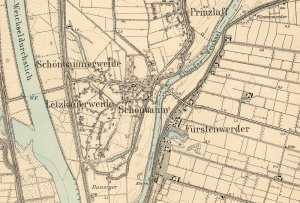
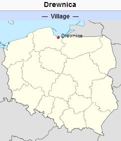
Schönbaum (now known as Drewnica; coordinates: 54.2874, 18.9606 [54° 17′ 14″ N, 18° 57′ 38″ E]; population in 1905, 431; in 2012, 840) is located approximately 13 kilometres (8 miles) north-west of Nowy Dwór Gdański (Tiegenhof) and 24 km (15 mi.) south-east of the regional capital Gdańsk (Danzig). It was situated on the west bank of the Szkarpawa River (Elbinger Weichsel) across from Fürstenwerder.
In the 2nd half of the 13th century, the area of Schönbaum constituted a border between the Teutonic Knights' estates and the Duchy of Pomerania. After eastern Pomerania was conquered by the Teutonic Knights, the Order began an intensive colonization of the region, including the construction of flood banks. This work was most intensive between 1325 and ca. 1350. The village of Schönbaum was granted privileges at the beginning of the 2nd half of the 14th century, and was first mentioned in historical documents in 1359. In ca. 1400, the village had 2 mills and 2 inns. In 1454, the village was incorporated into the territories of the city of Danzig.
In 1627, the Swedish army began to erect fortifications in place of a medieval inn located to the south of the Vistula fork. Later, the fortifications were taken over by Danzig, re-conquered by the Swedes in 1656, and finally besieged, captured, and demolished by the Danzig army in 1659. The military activities destroyed the area, including the village. Schönbaum was rebuilt by colonists who settled in the region under the emphyteutic contract, allowing for the long-term lease of the land. In 1771, the village had 21 włókas and 17 morgas (387.22 hectares) of farmland divided among 10 tenants. In its southern section, the village had 12 włókas and 6 morgas (219.04 ha.) of farmland divided among 11 tenants.
Until 1772 Schönbaum was part of the Kingdom of Poland. The First Partition of Poland in 1772 resulted in the creation of a new province in 1773, called West Prussia, in which Schönbaum was located. Schönbaum was situated in the district (Kreis) of Danzig from 1818 until 1887, when the district of Danziger Niederung was established. In 1920 the village came under the jurisdiction of the Free City of Danzig. The village came under the control of Nazi Germany during World War II until February 1945, when it was occupied by Soviet forces and returned to Poland. Today it is a village in the administrative district of Gmina Stegna, within Nowy Dwór Gdański County, Pomeranian Voivodeship.
In 1820, the village had 301 residents, including 11 Mennonites. By the end of the 19th century, Drewnica had 414 residents, including 9 Mennonites.
Mennonites who were residents of Schönbaum were members of the Bärwalde Mennonite Church.
Bibliography
Stowarzyszenie Konserwatorów Zabytków. "Drewnica." Catalogue of Monuments of Dutch Colonization in Poland. 2005. Web. 30 November 2012. http://holland.org.pl/art.php?kat=obiekt&id=313&lang=en.
Wikipedia. "Drewnica, Nowy Dwór Gdański County." Web. 30 November 2012. http://en.wikipedia.org/wiki/Drewnica,_Nowy_Dw%C3%B3r_Gda%C5%84ski_County.
Wolf, Hans-Jürgen. "Familienforschung in Westpreußen." Web. 23 June 2020. http://www.westpreussen.de/pages/forschungshilfen/ortsverzeichnis/details.php.
Maps
Map:Drewnica, Pomeranian Voivodeship, Poland
| Author(s) | Richard D Thiessen |
|---|---|
| Date Published | November 2012 |
Cite This Article
MLA style
Thiessen, Richard D. "Schönbaum (Pomeranian Voivodeship, Poland)." Global Anabaptist Mennonite Encyclopedia Online. November 2012. Web. 23 Nov 2024. https://gameo.org/index.php?title=Sch%C3%B6nbaum_(Pomeranian_Voivodeship,_Poland)&oldid=168703.
APA style
Thiessen, Richard D. (November 2012). Schönbaum (Pomeranian Voivodeship, Poland). Global Anabaptist Mennonite Encyclopedia Online. Retrieved 23 November 2024, from https://gameo.org/index.php?title=Sch%C3%B6nbaum_(Pomeranian_Voivodeship,_Poland)&oldid=168703.
©1996-2024 by the Global Anabaptist Mennonite Encyclopedia Online. All rights reserved.

