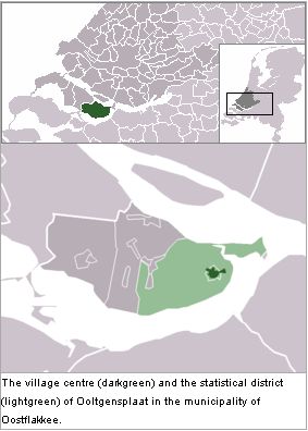
Ooltgensplaat (Zuid-Holland, Netherlands)

Ooltgensplaat, a village in the Dutch province of South Holland on the island Goeree-Overflakkee (coordinates: 51° 41′ 0″ N, 4° 21′ 0″ E), where there was once a Mennonite congregation in conjunction with near-by Bommel. The Mennonites of Ooltgensplaat had some difficulty in 1622 in performing their marriages, which had hitherto been done according to their old customs. By 1676 the congregation had died out.
See also Bommel and Ooltgensplaat (Zuid-Holland , Netherlands)
Bibliography
Doopsgezinde Bijdragen (1899): 183; (1908): 114.
Hege, Christian and Christian Neff. Mennonitisches Lexikon. Frankfurt & Weierhof: Hege; Karlsruhe; Schneider, 1913-1967: v. III, 305.
Hoop Scheffer, Jacob Gijsbert de. Inventaris der Archiefstukken berustende bij de Vereenigde Doopsgezinde Gemeente to Amsterdam. 2 v. Amsterdam: Uitgegeven en ten geschenke aangeboden door den Kerkeraad dier Gemeente, 1883-1884: II, 2, No. 298 f.
Maps
Map:Ooltgensplaat (Zuid-Holland, Netherlands)
| Author(s) | Nanne van der Zijpp |
|---|---|
| Date Published | 1959 |
Cite This Article
MLA style
van der Zijpp, Nanne. "Ooltgensplaat (Zuid-Holland, Netherlands)." Global Anabaptist Mennonite Encyclopedia Online. 1959. Web. 3 Feb 2026. https://gameo.org/index.php?title=Ooltgensplaat_(Zuid-Holland,_Netherlands)&oldid=76667.
APA style
van der Zijpp, Nanne. (1959). Ooltgensplaat (Zuid-Holland, Netherlands). Global Anabaptist Mennonite Encyclopedia Online. Retrieved 3 February 2026, from https://gameo.org/index.php?title=Ooltgensplaat_(Zuid-Holland,_Netherlands)&oldid=76667.
Adapted by permission of Herald Press, Harrisonburg, Virginia, from Mennonite Encyclopedia, Vol. 4, p. 68. All rights reserved.
©1996-2026 by the Global Anabaptist Mennonite Encyclopedia Online. All rights reserved.
