Difference between revisions of "Madhya Pradesh State (India)"
| [unchecked revision] | [checked revision] |
GameoAdmin (talk | contribs) (CSV import - 20130820) |
GameoAdmin (talk | contribs) (CSV import - 20130823) |
||
| Line 1: | Line 1: | ||
| − | [[File:ME5_425.jpg|300px|thumb|right|''Madhya Pradesh, India | + | [[File:ME5_425.jpg|300px|thumb|right|''Madhya Pradesh, India |
Mennonite Encyclopedia 5, | Mennonite Encyclopedia 5, | ||
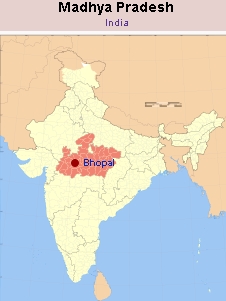
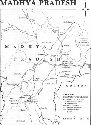
| − | p. 425 | + | p. 425 '']] [[File:Madhya%20Pradesh.jpg|300px|thumb|right|''Source: [http://en.wikipedia.org/wiki/Image:India_Madhya_Pradesh_locator_map.svg Wikipedia Commons ]'']] Area: 308,252 sq. km., population: 52,178,844 (1956); 66,180,000 (ca. 1991); capital: Bhopal; Principal language: Hindi. The economy of Madhya Pradesh is primarily agricultural with nearly 80 percent of the population living in villages. Over 42.5 percent of the land is arable and 14 percent is irrigated. Forests cover nearly 32 percent of the state. The state is divided into 50 districts. There are seven major river systems. Before 2000 Mennonite churches are scattered in the five southeastern districts, viz., Rajandgaon, [[Durg (Chhattisgarh, India)|Durg]], Raipur, Bilaspur, and Surguja. However, on 1 November 2000 the 16 Chhattisgarhi-speaking southeastern districts, including the five previously mentioned, formed the state of Chhattisgarh. |
| − | |||
| − | '']] [[File:Madhya%20Pradesh.jpg|300px|thumb|right|''Source: [http://en.wikipedia.org/wiki/Image:India_Madhya_Pradesh_locator_map.svg Wikipedia Commons] | ||
| − | |||
| − | '']] Area: 308,252 sq. km., population: 52,178,844 (1956); 66,180,000 (ca. 1991); capital: Bhopal; Principal language: Hindi. The economy of Madhya Pradesh is primarily agricultural with nearly 80 percent of the population living in villages. Over 42.5 percent of the land is arable and 14 percent is irrigated. Forests cover nearly 32 percent of the state. The state is divided into 50 districts. There are seven major river systems. Before 2000 Mennonite churches are scattered in the five southeastern districts, viz., Rajandgaon, [[Durg (Chhattisgarh, India)|Durg]], Raipur, Bilaspur, and Surguja. However, on 1 November 2000 the 16 Chhattisgarhi-speaking southeastern districts, including the five previously mentioned, formed the state of Chhattisgarh. | ||
See also [[India|India]]; [[Mennonite Church in India|Mennonite Church in India]]; [[Bharatiya General Conference Mennonite Kalisiya |Bharatiya General Conference Mennonite Kalisiya]]. | See also [[India|India]]; [[Mennonite Church in India|Mennonite Church in India]]; [[Bharatiya General Conference Mennonite Kalisiya |Bharatiya General Conference Mennonite Kalisiya]]. | ||
Latest revision as of 14:08, 23 August 2013

Area: 308,252 sq. km., population: 52,178,844 (1956); 66,180,000 (ca. 1991); capital: Bhopal; Principal language: Hindi. The economy of Madhya Pradesh is primarily agricultural with nearly 80 percent of the population living in villages. Over 42.5 percent of the land is arable and 14 percent is irrigated. Forests cover nearly 32 percent of the state. The state is divided into 50 districts. There are seven major river systems. Before 2000 Mennonite churches are scattered in the five southeastern districts, viz., Rajandgaon, Durg, Raipur, Bilaspur, and Surguja. However, on 1 November 2000 the 16 Chhattisgarhi-speaking southeastern districts, including the five previously mentioned, formed the state of Chhattisgarh.
See also India; Mennonite Church in India; Bharatiya General Conference Mennonite Kalisiya.
Bibliography
India 1985, compiled and edited by Research and Reference Division, Ministry of Information and Broadcasting, Government of India. New Delhi: Allied Printers, 1986: 579-581.
Juhnke, James C. A People of Mission: A History of General Conference Mennonite Overseas Missions. Newton, KS: Faith and Life, 1979: 17-43 passim.
Lapp, John Allen. The Mennonite Church in India, 1897-1962, Studies in Anabaptist and Mennonite History, vol. 14. Scottdale, PA: Herald Press, 1972.
| Author(s) | Pyarelal J Malagar |
|---|---|
| Date Published | 1987 |
Cite This Article
MLA style
Malagar, Pyarelal J. "Madhya Pradesh State (India)." Global Anabaptist Mennonite Encyclopedia Online. 1987. Web. 23 Nov 2024. https://gameo.org/index.php?title=Madhya_Pradesh_State_(India)&oldid=92519.
APA style
Malagar, Pyarelal J. (1987). Madhya Pradesh State (India). Global Anabaptist Mennonite Encyclopedia Online. Retrieved 23 November 2024, from https://gameo.org/index.php?title=Madhya_Pradesh_State_(India)&oldid=92519.
Adapted by permission of Herald Press, Harrisonburg, Virginia, from Mennonite Encyclopedia, Vol. 5, p. 533. All rights reserved.
©1996-2024 by the Global Anabaptist Mennonite Encyclopedia Online. All rights reserved.

