Difference between revisions of "Montauerweide (Pomeranian Voivodeship, Poland)"
| [checked revision] | [checked revision] |
m (Text replace - "a1_last=van der Zijpp|a1_first=Nanne" to "a1_last=Zijpp|a1_first=Nanne van der") |
m (Expanded article and added categories; added image.) |
||
| Line 1: | Line 1: | ||
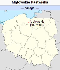
| − | [[File:Matowskie%20Pastwiska.jpg|300px|thumb|right|''Source: [http://en.wikipedia.org/wiki/M%C4%85towskie_Pastwiska Wikipedia Commons]'']] | + | [[File:Matowskie%20Pastwiska.jpg|300px|thumb|right|''Montauerweide (now Mątowskie Pastwiska, Poland).<br /> |
| + | Source: [http://en.wikipedia.org/wiki/M%C4%85towskie_Pastwiska Wikipedia Commons]'']] | ||
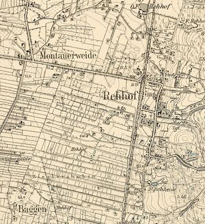
| + | [[File:Rehhof1913.jpg|300px|thumbnail|left|''Detailed map of Rehhof, ca. 1913.<br /> | ||
| + | Source: [http://amzpbig.com/maps/2179_Rehhof_1913.jpg Archiwum Map Zachodniej Polski]''.]] | ||
| + | Montauerweide (also known as Pastwisko Montki, Pastwisko Przy Montowach, Montowskie Pastwisko, Muntauerweyde, and Montauer Weide; now known as Mątowskie Pastwiska; coordinates: 53.84743, 18.93683 [53° 50′ 50″ N, 18° 56′ 53″ E]; population in 1905, 254; in 2013, 200) is located 12.8 kilometres (km) (7.9 miles) north of Kwidzyn ([[Marienwerder (Pomeranian Voivodeship, Poland)|Marienwerder]]), 22.0 km (13.7 miles) south south-west of Malbork ([[Marienburg (Pomeranian Voivodeship, Poland)|Marienburg]]), 28.6 km (17.8 miles) east south-east of Starogard Gdański (Preußisch Stargard), 29.5 km (18.3 miles) south south-east of Tczew ([[Dirschau (Pomeranian Voivodeship, Poland)|Dirschau]]), and approximately 61 km (38 miles) south of the regional capital Gdańsk ([[Danzig (Poland)|Danzig]]). | ||
| + | |||
| + | In the 17th century, the pastures situated in the area of what eventually became Mountauerweide were leased to Dutch settlers from [[Gross Montau (Pomeranian Voivodeship, Poland)|Groß Montau]]. At the end of the 18th century, the starost of Sztum, Tekla Bielińska, leased the area to Mennonites under the Emphyteusis Law (the right to the enjoyment of property with a given stipulation that the property will be improved or maintained in an agreed upon manner). | ||
| + | |||
| + | Until 1772 Montauerweide was located in what was known as Royal Prussia (also known as Polish Prussia) in the Kingdom of [[Poland]]. The First Partition of Poland in 1772 resulted in the creation of a new province on 31 January 1773, called [[West Prussia]], in which the village was located. Montauerweide was situated in the district (Kreis) of Stuhm in Regierungsbezirk Marienwerder until the end of World War I, when it came under the jurisdiction of [[East Prussia]]. The village came under the control of Nazi Germany during World War II until March 1945, when it was occupied by Soviet forces and returned to Poland. In 2014 Mountauerweide (now Mątowskie Pastwiska) was a village in the administrative district of Gmina Ryjewo, within Kwidzyn County, Pomeranian Voivodeship, in northern Poland. | ||
| + | |||
| + | In the 1776 Prussian census, there were 34 Mennonite families listed as residing in Montauerweide with the following surnames: [[Balzer (Baltzer) family|Baltzer]], [[Bartel (Bartels, Barthel, Bartol, Bartelmes, Bartelmeus, Bartholomäus) family|Bartel]], Casper, [[Claassen (Claasen, Classen, Claesz, Claussen, Klaassen, Klassen, Klaeszen) family|Claassen]], Cornelius, [[Ediger (Edger, Oedger) family|Ediger]], [[Ewert family name|Ewert]], [[Foth (Voth, Voet) family|Fodt]], Frantz, Haltrechter, [[Harms (Harm, Harmssen, Harmsen) family|Harms]], Jantzen, [[Nickel (Nikkel, Neckel) family|Nickel]], [[Pauls (Pauels, Pauwels, Paulsen) family|Pauls]], [[Penner family name|Penner]], Plenert, Purau, Ross, Schmidt, Siebert, [[Stobbe family|Stobbe]], Unrau, and [[Willms family|Willms]]. The 1935 Tragheimerweide Mennonite Church membership list states that the following families lived in Montauerweide: Dirks, Dyck, Erasmus, Ewert, Foth, Franzen, Janzen, Reimer, and Unrau. | ||
= Bibliography = | = Bibliography = | ||
| − | + | Stowarzyszenie Konserwatorów Zabytków. "Mątowskie Pastwiska." Catalogue of Monuments of Dutch Colonization in Poland. 2005. Web. http://holland.org.pl/art.php?kat=obiekt&id=520&lang=en. | |
| − | |||
| − | "Mątowskie Pastwiska." | ||
Szper, Felicia. <em class="gameo_bibliography">Nederlandsche nederzettingen in West-Pruisen gedurende den poolschen tijd</em>. Enkhuizen : P. Bais, 1913: 122 f. | Szper, Felicia. <em class="gameo_bibliography">Nederlandsche nederzettingen in West-Pruisen gedurende den poolschen tijd</em>. Enkhuizen : P. Bais, 1913: 122 f. | ||
| Line 9: | Line 17: | ||
Wiebe, Herbert. <em class="gameo_bibliography">Das Siedlungswerk niederländischer Mennoniten im Weichseltal zwischen Fordon und Weissenberg bis zum Ausgang des 18. Jahrhunderts</em>. Marburg a.d. Lahn : Johann Gottfried Herder-Institut, 1952: 40, 84 f. | Wiebe, Herbert. <em class="gameo_bibliography">Das Siedlungswerk niederländischer Mennoniten im Weichseltal zwischen Fordon und Weissenberg bis zum Ausgang des 18. Jahrhunderts</em>. Marburg a.d. Lahn : Johann Gottfried Herder-Institut, 1952: 40, 84 f. | ||
| + | Wikipedia. "Mątowskie Pastwiska." Web. 30 September 2012. [http://en.wikipedia.org/wiki/Mątowskie Pastwiska http://en.wikipedia.org/wiki/Mątowskie Pastwiska]. | ||
| + | |||
| + | Wolf, Hans-Jürgen. "Familienforschung in Westpreußen." Web. 29 September 2012. http://www.westpreussen.de/cms/ct/ortsverzeichnis/details.php?ID=4338. | ||
= Maps = | = Maps = | ||
[[Map:Mątowskie Pastwiska (Pomeranian Voivodeship, Poland)|Map:Mątowskie Pastwiska (Pomeranian Voivodeship, Poland)]] | [[Map:Mątowskie Pastwiska (Pomeranian Voivodeship, Poland)|Map:Mątowskie Pastwiska (Pomeranian Voivodeship, Poland)]] | ||
| − | {{GAMEO_footer|hp=Vol. 3, p. 744|date=September | + | {{GAMEO_footer|hp=Vol. 3, p. 744|date=September 2014|a1_last=Zijpp|a1_first=Nanne van der|a2_last=Thiessen|a2_first=Richard D.}} |
| + | [[Category:Places]] | ||
| + | [[Category:Cities, Towns, and Villages]] | ||
| + | [[Category:Cities, Towns, and Villages in Poland]] | ||
Revision as of 23:33, 11 September 2014
Montauerweide (also known as Pastwisko Montki, Pastwisko Przy Montowach, Montowskie Pastwisko, Muntauerweyde, and Montauer Weide; now known as Mątowskie Pastwiska; coordinates: 53.84743, 18.93683 [53° 50′ 50″ N, 18° 56′ 53″ E]; population in 1905, 254; in 2013, 200) is located 12.8 kilometres (km) (7.9 miles) north of Kwidzyn (Marienwerder), 22.0 km (13.7 miles) south south-west of Malbork (Marienburg), 28.6 km (17.8 miles) east south-east of Starogard Gdański (Preußisch Stargard), 29.5 km (18.3 miles) south south-east of Tczew (Dirschau), and approximately 61 km (38 miles) south of the regional capital Gdańsk (Danzig).
In the 17th century, the pastures situated in the area of what eventually became Mountauerweide were leased to Dutch settlers from Groß Montau. At the end of the 18th century, the starost of Sztum, Tekla Bielińska, leased the area to Mennonites under the Emphyteusis Law (the right to the enjoyment of property with a given stipulation that the property will be improved or maintained in an agreed upon manner).
Until 1772 Montauerweide was located in what was known as Royal Prussia (also known as Polish Prussia) in the Kingdom of Poland. The First Partition of Poland in 1772 resulted in the creation of a new province on 31 January 1773, called West Prussia, in which the village was located. Montauerweide was situated in the district (Kreis) of Stuhm in Regierungsbezirk Marienwerder until the end of World War I, when it came under the jurisdiction of East Prussia. The village came under the control of Nazi Germany during World War II until March 1945, when it was occupied by Soviet forces and returned to Poland. In 2014 Mountauerweide (now Mątowskie Pastwiska) was a village in the administrative district of Gmina Ryjewo, within Kwidzyn County, Pomeranian Voivodeship, in northern Poland.
In the 1776 Prussian census, there were 34 Mennonite families listed as residing in Montauerweide with the following surnames: Baltzer, Bartel, Casper, Claassen, Cornelius, Ediger, Ewert, Fodt, Frantz, Haltrechter, Harms, Jantzen, Nickel, Pauls, Penner, Plenert, Purau, Ross, Schmidt, Siebert, Stobbe, Unrau, and Willms. The 1935 Tragheimerweide Mennonite Church membership list states that the following families lived in Montauerweide: Dirks, Dyck, Erasmus, Ewert, Foth, Franzen, Janzen, Reimer, and Unrau.
Bibliography
Stowarzyszenie Konserwatorów Zabytków. "Mątowskie Pastwiska." Catalogue of Monuments of Dutch Colonization in Poland. 2005. Web. http://holland.org.pl/art.php?kat=obiekt&id=520&lang=en.
Szper, Felicia. Nederlandsche nederzettingen in West-Pruisen gedurende den poolschen tijd. Enkhuizen : P. Bais, 1913: 122 f.
Wiebe, Herbert. Das Siedlungswerk niederländischer Mennoniten im Weichseltal zwischen Fordon und Weissenberg bis zum Ausgang des 18. Jahrhunderts. Marburg a.d. Lahn : Johann Gottfried Herder-Institut, 1952: 40, 84 f.
Wikipedia. "Mątowskie Pastwiska." Web. 30 September 2012. Pastwiska http://en.wikipedia.org/wiki/Mątowskie Pastwiska.
Wolf, Hans-Jürgen. "Familienforschung in Westpreußen." Web. 29 September 2012. http://www.westpreussen.de/cms/ct/ortsverzeichnis/details.php?ID=4338.
Maps
Map:Mątowskie Pastwiska (Pomeranian Voivodeship, Poland)
| Author(s) | Nanne van der Zijpp |
|---|---|
| Richard D. Thiessen | |
| Date Published | September 2014 |
Cite This Article
MLA style
Zijpp, Nanne van der and Richard D. Thiessen. "Montauerweide (Pomeranian Voivodeship, Poland)." Global Anabaptist Mennonite Encyclopedia Online. September 2014. Web. 16 Apr 2024. https://gameo.org/index.php?title=Montauerweide_(Pomeranian_Voivodeship,_Poland)&oldid=124570.
APA style
Zijpp, Nanne van der and Richard D. Thiessen. (September 2014). Montauerweide (Pomeranian Voivodeship, Poland). Global Anabaptist Mennonite Encyclopedia Online. Retrieved 16 April 2024, from https://gameo.org/index.php?title=Montauerweide_(Pomeranian_Voivodeship,_Poland)&oldid=124570.
Adapted by permission of Herald Press, Harrisonburg, Virginia, from Mennonite Encyclopedia, Vol. 3, p. 744. All rights reserved.
©1996-2024 by the Global Anabaptist Mennonite Encyclopedia Online. All rights reserved.


