Difference between revisions of "Fichthorst (Warmian-Masurian Voivodeship, Poland)"
| [checked revision] | [checked revision] |
GameoAdmin (talk | contribs) (CSV import - 20130823) |
AlfRedekopp (talk | contribs) |
||
| (One intermediate revision by one other user not shown) | |||
| Line 1: | Line 1: | ||
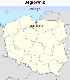
| − | [[File:Fichthorst.jpg|300px|thumb|right|''Fichthorst (now Jegłownik, Poland) | + | [[File:Fichthorst.jpg|300px|thumb|right|''Fichthorst (now Jegłownik, Poland).<br /> |
| − | + | Source: [http://en.wikipedia.org/wiki/Jeg%C5%82ownik Wikipedia Commons]'']] | |
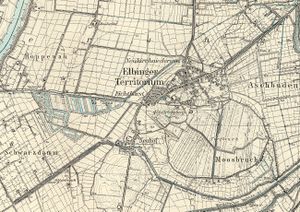
| − | Source: [http://en.wikipedia.org/wiki/Jeg%C5%82ownik Wikipedia Commons]'']] | + | [[File:ElbingerTerritorium.jpg|300px|thumbnail|left|''Detailed map of Elbinger Territorium, ca. 1931.<br /> |
| + | Source: [http://amzpbig.com/maps/1881_Zeyer_1931.jpg Archiwum Map Zachodniej Polski]''.]] | ||
| + | Fichthorst (also known as Elbinger Territorium; now known as Jegłownik; coordinates: 54.1225, 19.2948 [54° 7′ 20″ N, 19° 17′ 41″ E]); is located approximately 7.5 kilometers (5 miles) south-west of Elbląg ([[Elbing (Warmian-Masurian Voivodeship, Poland)|Elbing]]), 15 km. (9 miles) south-east of Nowy Dwór Gdański ([[Tiegenhof (Pomeranian Voivodeship, Poland)|Tiegenhof]]), and 19 km. (11 miles) north-east of Malbork ([[Marienburg (Pomeranian Voivodeship, Poland)|Marienburg]]). | ||
The settlement now known as Jegłownik was established in 1595 in a former forest. Initially, it consisted of dispersed settlements. In time, these settlements formed a single village - an <em>Olęder</em> (Dutch) settlement. In 1641, the residents erected a church and established a cemetery. Fichthorst, along with Fridrichsberg, formed the western section of the settlement, located on the southern side of the road to Malbork (Marienburg). The village was expanded after the neighboring forests had been cleared in 1799/1800 and 124 plots were allocated for tenant farms. A windmill was built on a hill at the southern end of the village. | The settlement now known as Jegłownik was established in 1595 in a former forest. Initially, it consisted of dispersed settlements. In time, these settlements formed a single village - an <em>Olęder</em> (Dutch) settlement. In 1641, the residents erected a church and established a cemetery. Fichthorst, along with Fridrichsberg, formed the western section of the settlement, located on the southern side of the road to Malbork (Marienburg). The village was expanded after the neighboring forests had been cleared in 1799/1800 and 124 plots were allocated for tenant farms. A windmill was built on a hill at the southern end of the village. | ||
| Line 15: | Line 17: | ||
Wikipedia. "Jegłownik." Web. 9 February 2013. [http://en.wikipedia.org/wiki/Jegłownik http://en.wikipedia.org/wiki/Jegłownik]. | Wikipedia. "Jegłownik." Web. 9 February 2013. [http://en.wikipedia.org/wiki/Jegłownik http://en.wikipedia.org/wiki/Jegłownik]. | ||
| − | Wolf, Hans-Jürgen. "Familienforschung in Westpreußen." Web. | + | Wolf, Hans-Jürgen. "Familienforschung in Westpreußen." Web. 22 June 2020. http://www.westpreussen.de/pages/forschungshilfen/ortsverzeichnis/details.php?ID=1407. |
= Maps = | = Maps = | ||
[[Map:Jegłownik, Warmian-Masurian Voivodeship, Poland|Map:Jegłownik, Warmian-Masurian Voivodeship, Poland]] | [[Map:Jegłownik, Warmian-Masurian Voivodeship, Poland|Map:Jegłownik, Warmian-Masurian Voivodeship, Poland]] | ||
{{GAMEO_footer|hp=|date=February 2013|a1_last=Thiessen|a1_first=Richard D|a2_last=|a2_first=}} | {{GAMEO_footer|hp=|date=February 2013|a1_last=Thiessen|a1_first=Richard D|a2_last=|a2_first=}} | ||
| + | [[Category:Cities, Towns, and Villages]] | ||
| + | [[Category:Cities, Towns, and Villages in Poland]] | ||
Latest revision as of 00:42, 23 June 2020
Fichthorst (also known as Elbinger Territorium; now known as Jegłownik; coordinates: 54.1225, 19.2948 [54° 7′ 20″ N, 19° 17′ 41″ E]); is located approximately 7.5 kilometers (5 miles) south-west of Elbląg (Elbing), 15 km. (9 miles) south-east of Nowy Dwór Gdański (Tiegenhof), and 19 km. (11 miles) north-east of Malbork (Marienburg).
The settlement now known as Jegłownik was established in 1595 in a former forest. Initially, it consisted of dispersed settlements. In time, these settlements formed a single village - an Olęder (Dutch) settlement. In 1641, the residents erected a church and established a cemetery. Fichthorst, along with Fridrichsberg, formed the western section of the settlement, located on the southern side of the road to Malbork (Marienburg). The village was expanded after the neighboring forests had been cleared in 1799/1800 and 124 plots were allocated for tenant farms. A windmill was built on a hill at the southern end of the village.
Until 1772 the village was located in what was known as Royal Prussia (also known as Polish Prussia) in the Kingdom of Poland. The First Partition of Poland in 1772 resulted in the creation of a new province in 1773, called West Prussia, in which the village was located. The village was situated in the district (Kreis) of Elbing until the end of World War I, when it came under the jurisdiction of the German province of East Prussia. At the outbreak of World War II in 1939, it came under the control of Nazi Germany. In February 1945 it was occupied by Soviet forces and eventually returned to Poland. In 1946 Jegłownik was formed from four original settlements: Neukirchenniederung (known as Neukirch until the end of the 19th century), Fichthorst, Friedrichsberg, and Neuhof. In 2013 Jegłownik was a village in the administrative district of Gmina Gronowo Elbląskie, within Elbląg County, Warmian-Masurian Voivodeship.
In 1820, the village of Fichthorst had 402 residents, including 5 Mennonites.
Mennonites who were residents of Fichthorst were members of the Elbing-Ellerwald Mennonite Church.
Bibliography
Stowarzyszenie Konserwatorów Zabytków. "Jegłownik." Catalogue of Monuments of Dutch Colonization in Poland. 2005. Web. 9 February 2013. http://holland.org.pl/art.php?kat=obiekt&id=337&lang=en.
Wikipedia. "Jegłownik." Web. 9 February 2013. http://en.wikipedia.org/wiki/Jegłownik.
Wolf, Hans-Jürgen. "Familienforschung in Westpreußen." Web. 22 June 2020. http://www.westpreussen.de/pages/forschungshilfen/ortsverzeichnis/details.php?ID=1407.
Maps
Map:Jegłownik, Warmian-Masurian Voivodeship, Poland
| Author(s) | Richard D Thiessen |
|---|---|
| Date Published | February 2013 |
Cite This Article
MLA style
Thiessen, Richard D. "Fichthorst (Warmian-Masurian Voivodeship, Poland)." Global Anabaptist Mennonite Encyclopedia Online. February 2013. Web. 18 Apr 2024. https://gameo.org/index.php?title=Fichthorst_(Warmian-Masurian_Voivodeship,_Poland)&oldid=168477.
APA style
Thiessen, Richard D. (February 2013). Fichthorst (Warmian-Masurian Voivodeship, Poland). Global Anabaptist Mennonite Encyclopedia Online. Retrieved 18 April 2024, from https://gameo.org/index.php?title=Fichthorst_(Warmian-Masurian_Voivodeship,_Poland)&oldid=168477.
©1996-2024 by the Global Anabaptist Mennonite Encyclopedia Online. All rights reserved.

